20 December 2014

CIS FSK 200Bd/500


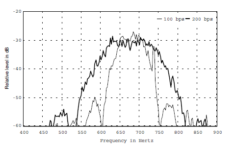
FSK 200Bd/500  mode is believed to be used by one of the Russian intelligence services. It transmits data using FSK (Frequency Shift Keying) modulation with the ITA-2 alphabet (with 1.5 stop bits) at a speed of 200 baud with a shift of 500 Hz.
FSK 200/500 messages are transmitted with fixed schedules on frequencies which change monthly. The latest information on the times and frequencies of these schedules can be found online here.

Rivet can decode FSK 200/500 messages directly from a radio in USB mode connected to a soundcard line input or from a WAV file that is mono and with a sample rate of 8000 Hz. The program calibrates itself by looking at the incoming audio and then starts to decode and display the message on the screen. Once a message is decoding do not retune your radio until the message is complete.
A short recording of a an FSK/200/500 transmission may heard here

When there is no message to send in a schedule the line 

 00000++++++++++162)5761

will be sent continuously for seven minutes as in the following decode output from Rivet:
 
FSK/200/500 null traffic
 When there is a message offline encryption is sent which starts like this:

00000++++++++++188=8331
52281013891141343 =8432
92874574809254333 =8573
814347960943078155=8794

The number to the left of the = sign appears to be the encrypted traffic and consists of 17 or 18 digits. The number to the right is interesting also though. The last digits of this is the line number which you can see incrementing. The messages ends like this:

28870268039372698 =81275
423345851935701126=86276
88837514787689596 =81277
26158186121423068 )57678

Certain 3 digit codes appear to have special meanings. The ones we have come across so far are:

162 Start of a null message
188 Start of a message
576 End of message or null

 (source: Rivet wiki)


15 December 2014

DPRK-ARQ 600/600 (KEGURI)

Known as DPRK-ARQ and DPRK-FEC, DPRK-ARQ 600bd/600 is a proprietary two-tone FSK system with a 600 Hz shift. This system is used by the Democratic People Republic of Korea (so the abbreviation DPRK) with 600 Baud and, as said, 600 Hz shift for their HF diplomatic traffic in ARQ mode on LSB.
DPRK-ARQ 600/600 sonagram and spectum

The block length is 217 ms, the pause 323 ms so that the total packet has a length of 540 ms. Each bit has a length of 1.67 ms so that one packet has 130 bit.


Sometimes they use DPRK-ARQ 1200 with 1200 Baud and 1200 Hz shift (DPRK-ARQ 1200/1200):


14 December 2014

Russian Navy radio Centers

Here is a list of the main Russian Navy radio Centers, set your web/mail browser to read cyrillic in order to see the Russian names of these sites correctly.

Radiocoverage area World wide
N  р/с 2201 (poss 2200)

Москва / Moscow
РИВ / RIW (+ RJE56)
Прогресс / Progress


Radiocoverage area Northern Fleet,
Arctic regions, North Atlantic Ocean, North sea, Norwegian Sea, white Sea, Northern inland waterways
N  р/с 2202

Североморск /Severomorsk
РИТ / RIT (+ RJH57 ?)
Вольфрам /Wolfram

Северодвинск / Severodvinsk
РЙД-99  / RJD99
Цветок / Swetok, "Flower"

Иоканьга*  / Iokanga aka Jagernaja / Ostrovnoj aka Gremikha aka Murmansk-140
РЙД-80  / RJD80
Светлана / Svetlana

Полярный   / Polyarny
РИР-2  / RIR2
Природа / Priroda, "Nature"

Мурманск  / Murmansk
РЙД-56  / RJD56
Флюгер / Flüger, "Vane"

Radiocoverage area Baltic Fleet

Baltic Sea, North sea, English Channel, Inland waterways
N  р/с 2203

Калининград / Kaliningrad
РМП  / RMP (+RJD71?)
Вестник / Westnik, "Herald", "Messenger"

С-Петербург / St. Petersburg
РЙД-85  / RJD85
Скакун  / Skakun, "Race horse", "Jumper"

Балтийск  / Baltiysk
РЙД-69  / RJD69
Искатель / Iskatelx, "Seeker"

Radiocoverage area Black Sea Fleet
Black Sea, Mediterranean Sea, Caspian Sea, Red Sea, inland waterways
N  р/с 2204

Севастополь / Sevastopol
РЦЖ / RCV  
Гвоздика / Gwozdika, "Cloves"

Новороссийск / Novorossiysk
РЙЕ-65  / RJE65
Тополь / Topolx, "White Poplar"

Radiocoverage area Caspian Flotilla
Caspian Sea, inland waterways
N   р/с 2205

Астрахань  / Astrakhan
РЙД-52 / RJD52
Зазор / Zazor, "Clearance" or poss "Gap"

Radiocoverage area Pacific Fleet
North Pacific Ocean, South Pacific Oceans, Bering Sea, inland waterways
N   р/с 2206

Владивосток / Vladivostok
РЙС   / RJS
Грейдер / Grejder "Grader"

Стрелок  / Strelok aka Pavlovsk Bay
РЙД-97  / RJD97
Чинара / Öjnara "Sycamore"

П.-Камчатский  / Petropavlomsk Kamchatskiy
РЦЦ  / RCC
Деканат / Dekanat "Deanery (Deans office)"

Совгавань /  Sowgwanx aka Sovjetskaya Gavan
РЙД-93  / RJD93
Флейта / Flejta "Flute"

Владивосток / Vladivostok
РЙЦ-60  / RJC60
Юрист / Ürist "Lawyer (Jurist)"


Radiocoverage area Indian Ocean
Indian Ocean, South Atlantic Ocean, inland waterways
N   р/с 2207

Бишкек  / Bishkek
РЙХ-25  / RJH25
Сибиряк  / Sibiräk "Siberian"
From my good friend Trond Jacobsen in Norway.

6 December 2014

The Snake Charmer: a flute in HF


the signal has been spotted on 16927.0 KHz/USB from 1310 UTC, it's the so-called "snake charmer" here in the 16-step MFSK version. The transmission is likely sourced from HEB/WLO/WPG as reported in a detailed description reported here, although the author reports the 64 and 32 tones versions.
Below the 30 minutes long max-hold FFT spectrum that exhibits 16 tones, approximately 65 Hz spaced, in a range of 10 dB:

fig. 1 - max hold FFT spectrum

The signal is believed to be a test signal of some kind from WLO, WPG, or maybe HEB.  I just asked my friend MIke Chace-Ortiz (mco) and he replied that there have been 3 channels, all allocated to WPG active on 16MHz recently. The 22819.0 frequency (on USB) also remains active, usually with carrier from WLO direction but this also carries the same odd signal from time to time.

1 December 2014

my very first radio

I began to tune HF stations (48 meter band) using this simple-but-good radio receiver and a long wire antenna out of my window. I still love it !


18 November 2014

CIS FSK 200/1000


FSK 200/1000 is a technical name for a digital mode used by Russian Intelligence and possibly also Diplomatic stations. The name stands for its baud rate and shift - 200 bd speed, 1000 Hz shift between tones.

Aggiungi didascalia

The messages are encrypted bitstreams, sent in 288-bit blocks. Each block begins with control bytes 0x7D 0x12 0xB0 0xE6. The first two blocks of each message are significant, containing information on the amount of blocks, communication link ID, day of the month, serial number, message type, possibly the amount of encoded groups, and encoded decryption information.
A short recording may be heard  here

Below is an example of a FSK 200/1000 decoded transmission: you can see the mentioned keys (link ID, day of the month,...): reception was made on 17 November at 2020z, on 8123.0 KHz/USB:

----------------------------------------------------------
Block No 0 : Total Message Size 4 blocks : This transmission contains one message.
7d,12,b0,e6,00,00,00,00,00,00,60,00,10,00,00,00,00,08,20,04,00,04,00,08,40,0b,40,06,70,03,70,0e,20,0f,90,08
Block No 1  : Link ID 28680  : 17th of month  : Msg Number 002 : Msg Type 07145 : Group Count (?) 4
22796 00000 00000 00606 56197 35395 00893 60555
7d,12,b0,e6,00,33,15,00,b9,40,e0,e0,9c,10,7a,00,0a,02,00,05,82,0e,d8,0e,ba,3c,84,78,53,db,06,12,25,10,89,03
Block No 2
7d,12,b0,e6,00,55,00,00,00,00,00,00,00,00,00,00,00,0a,00,0f,00,0a,00,09,00,01,00,00,00,03,00,04,00,05,00,04
----------------------------------------------------------
Block No 0 : Total Message Size 2 blocks : This transmission contains 0 messages.
7d,12,b0,e6,00,00,00,00,00,00,30,00,08,00,00,00,00,04,10,02,00,02,00,04,20,05,a0,03,38,01,b8,07,10,07,c8,04
Block No 1  : Link ID 28680  : 17th of month  : Msg Number 002 : Msg Type 07145 : Group Count (?) 4
22796 00000 00000 00606 56197 35395 00893 60555
7d,12,b0,e6,00,33,15,00,b9,40,e0,e0,9c,10,7a,00,0a,02,00,05,82,0e,d8,0e,ba,3c,84,78,53,db,06,12,25,10,89,03
Block No 2
7d,12,b0,e6,00,55,00,00,00,00,00,00,00,00,00,00,00,0a,00,0f,00,0a,00,09,00,01,00,00,00,03,00,04,00,05,00,04
----------------------------------------------------------

FSK 200/1000 also has a concept of empty messages. These are always 4 blocks long, and include "00000" groups.
FSK 200/1000 operates in schedules of three transmissions, spaced 10 minutes apart.
The further transmissions are transmitted on lower frequencies. The frequency usage indicates worldwide operation. There also are unscheduled transmissions, using the communication link ID "00000", which may not repeat in regular manner.

FSK 200/1000 contents can be decoded using the free program Rivet, as in the following screenshot:

17 November 2014

XSL - the "Japanese Slot Machine"

Japanese Slot Machine (also named XSL or JSM) is a system thought to be from the Japanese Government or Self-Defense Force (Navy). Some have likened its weird sound to that of a Las Vegas slot machine, so the name Japanese Slot Machine.
I heard an XSL transmission on 16 November (at 2212z) on 8588.0 KHz/USB: see below a screenshot from my SDR Console during the reception.


Known Frequencies
4231.5 kHz     6417.0 kHz     8588.0 kHz        
4291.0 kHz     6445.1 kHz     8704.0 kHz


The signal transmits continuously on pairs of frequencies in the 4MHz, 6MHz and 8MHz bands, which places it firmly in the ITU bands allocated for Maritime use.
Reports show the signal to be stongest in the Far East, indicating an origin in that part of the World. Although the signals are weak in Europe, they can be monitored in the evenings on both the 6MHz and 8MHz frequncies. The poor reception makes analysis of the signal difficult.
An article in Monitoring Times, December 2002 was the first to identify these signals as Japanese Navy. Writing it the "Utility World" column, Hugh Stegman outlines his reasons for this claim. Firstly, direction-finding fixes indicated Japan at the source of the signals, although China and Russia were not ruled out.
Secondly, the frequencies correlate with those previously used by the Japanese Navy for eight-tone radio modems, some of which disappeared at the right time.
Finally, monitors travelling to Japan identified additional strong local frequencies, some of which were only operating on a part daily basis.

The mode being used is quadrature phase-shift keying (QPSK) , encrypted shore to ships traffic.  The mode is un-decodable: Sigmira doesn't really decode the information but only displays the "frames" and raw QPSK symbols.


It still remains a challenging and difficult signal to monitor at any reasonable strength in Europe.

The following is quoted from the Sigmira manual.
"With some investigation the symbol rate was determined to be 1600.00 baud. The regular ticking sound was found to be an exactly repeating sequence of symbols. Clearly that serves as a channel probe and frame synchronization pattern. 
One tick sound period is here defined as a "frame". Frames were found to consist of 140 QPSK symbols. So the frame rate is 11.42857 Hz. 
The probe/sync pattern is 28 symbols which is one fifth the number of symbols per frame. It is found that, during the repetitive melody idle time, the remaining symbols of a frame consist of four repetitions of another 28 symbol pattern. So a frame appears to consist of five "blocks" of 28 symbols. 

During idle time there is a finite set of symbol patterns that appear in the blocks. The patterns are designated here: ps, p0, p1, p2, p3, p4, p5, p6, p7, p8, p9, p10, and p11. The "ps" pattern is the probe/sync pattern. The rest are numbered roughly in the order of their frequency of occurrence. The "p0" pattern is most common. The melodic idle time consists of an exactly repeating sequence of 64 frames. A 64 frame sequence is called a "super frame" here. 

The duration of a super frame is 5.60000 seconds. The frame / block pattern of the idle super frame is presented in the following table. The melody arises from the regular repeated simple patterns of symbols/phases. The p10 pattern is all one phase. So it produces a single tone. The p11 pattern is also all one phase but 180 degrees from p10. The other patterns are somewhat more complex and result in different and multiple apparent tones."
 
A short recording of my XSL reception may be heard here
decoder Sigmira may be downloaded from the sigmira official site 


16 November 2014

XSQ - Guangzhou Coast Station


Guangzhou Coast Station is one of the China's largest coast station in southern China and was established in October 14, 1949.
Guangzhou coast station is directly under the Guangdong Maritime Safety Agency. The staff is 176 of employees people: 122 people in the post, four senior titles, intermediate title 12 people, technical staff of 76 people.

Main functions:

1, implementation of the party and state policies and directives and superior decisions;

2, responsible for the South China Sea maritime safety information broadcast, distress and safety duty and other services, to provide security communications for ships at sea;

3, provide maritime radio communication services and special communications tasks assigned by superiors for international and domestic shipping;

4, provide ship-shore communication technology and social counseling services, ship guided escrow and other public services;

5, take charge of the Guangdong Maritime Safety Administration water traffic safety supervision communications, information systems, communication lines, communication networks and other construction and maintenance;

6, in accordance with the authorization, responsible for issuing work within the jurisdiction of the ship station licens

From January 1, 2014, Guangzhou coast stations offer free boat ship - shore public (official) communications services.

 radio station long line facilities and equipment

Guangzhou coast station is a three-site formula coast station:

Wanqingsha: receiving station
Nangang: center console (located in Huangpu, Guangzhou Development Zone)
Luogang: transmitting station(Eastern Guangzhou City, covering about 35 thousand square meters)

and other nine minor base stations.


eMail: gzrdo@gzrdo.com
Address: Room 1101, No. 40, Guangzhou Bin Jiangxi
Radio Telephone: 020-83295815 Office Tel: 020-83295554 

Guangdong Coast VHF system server, automatic DSC, AIS terminal


6 November 2014

Swiss 2 x 100Bd/170Hz VFT system

fig 1

VFT 2 x FSK 100Bd/170Hz system used by Swiss Air Force, likely the modem is the "Telematik-Set TmS-430". Channels are simply arranged as in fig. 1.

fig. 2
fig. 3
fig. 4

3 November 2014

why HF ?


in the age of Internet and Satcom why they should still use HF?

Prior to the launch of communications satellites in the 1960s, high frequency (HF) radio was the principal means to communicate over the horizon. Satellite links permitted users to communicate at higher data rates, and over time HF was relegated to a backup role within the militaries of the United States, Western Europe, and the former Soviet Union. However, the limitations of satellites became clear in the Cold War era, as satellites were not only vulnerable to jamming and physical damage, but also required a supporting infrastructure that was expensive to build and maintain. The last two decades have resultantly seen resurgence in HF radio, led by a new generation of automated equipment with improved link reliability, connectivity, and speed that offered many of the benefits of satellite technology at a fraction of the overall cost. HF now serves as the principal backup in most ground- and ship-based configurations, and the primary backup in installations prioritizing lowest total cost of ownership.

Today, amidst the post 9/11 requirements for continuity of operations and a failsafe means of voice and data communication, HF equipment serves as a critical component in most emergency preparedness wireless communications plans. HF radio provides an additional layer of protection against total loss of communication when infrastructure-dependent communications are disabled, destroyed, or unavailable.

Benefits of HF Technology:

MINIMAL INFRASTRUCTURE REQUIREMENTS
An HF radio network requires absolutely no infrastructure. Unlike conventional land lines, cellular and satellite telephones, and Voice Over IP, an HF radio user can communicate with another HF radio user without any infrastructure apart from the equipment and housing area, minimizing both cost and susceptibility to damage.
   
MINIMAL COST OF OWNERSHIP
HF is the most economical means of failsafe communication. After the initial investment in equipment and installation is made, there are no call or line costs. Furthermore, such equipment is ruggedized and built to withstand extreme conditions over many years, thereby significantly reducing costs of the usage period.

TRUE HEMISPHERIC COVERAGE
HF, or short-wave, radio is the best suited technology to communicate over long distances. When coupled with solid-state kilowatt amplifiers, HF can serve as a primary or emergency means of communication to and from any point in the world.

SURE AND SECURE COMMUNICATIONS
For sensitive communications where security is essential, voice and data encryption is a readily available option with HF radio with differing levels of security based on the respective communications requirement.

FULL FEATURED
In addition to voice, HF radios come with options that allow for telephone, fax, email, and high speed data.

INTEROPERABILITY
HF radios can communicate with existing VHF and UHF systems, cellular telephones and land lines through developments in cross-patching technology.


[ source sunair ]

28 October 2014

DGPS: the new frontier of DXing ?

Differential Global Positioning System (DGPS) is an enhancement to Global Positioning System that provides improved location accuracy, from the 15-meter nominal GPS accuracy to about 10 cm (!) in case of the best implementations.
DGPS uses a network of fixed, ground-based reference stations to broadcast the difference between the positions indicated by the satellite systems and the known fixed positions. These stations broadcast the difference between the measured satellite pseudoranges and actual (internally computed) pseudoranges, and receiver stations may correct their pseudoranges by the same amount. The digital correction signal is typically broadcast locally over ground-based transmitters of shorter range. Just these stations are called DGPS Beacons.

DGPS serving marine navigation

DGPS serving inland users

Differential correction techniques are used to enhance the quality of location data gathered using global positioning system (GPS) receivers. Differential correction can be applied in real-time directly in the field or when postprocessing data in the office. Although both methods are based on the same underlying principles, each accesses different data sources and achieves different levels of accuracy. Combining both methods provides flexibility during data collection and improves data integrity.


Real-time DGPS
occurs when the base station calculates and broadcasts corrections for each satellite as it receives the data. The correction is received by the roving receiver via a radio signal if the source is land based or via a satellite signal if it is satellite based and applied to the position it is calculating. As a result, the position displayed and logged to the data file of the roving GPS receiver is a differentially corrected position.

Postprocessing Correction
Differentially correcting GPS data by postprocessing uses a base GPS receiver that logs positions at a known location and a rover GPS receiver that collects positions in the field. The files from the base and rover are transferred to the office processing software, which computes corrected positions for the rover's file. This resulting corrected file can be viewed in or exported to a GIS.


postprocessing


These signals can be found on LF, on the channels listed in the Marine Beacon Bandplan in Section Nine; in Europe the band covers 283.5 to 315 kHz, but in some other parts of the world 315 to 325 kHz are also used.  DGPS beacons are heard using G1D modulation with Minimum Shift Keying (MSK), a frequency shift keying mode with very small bandwidth, and their sound resembles a RTTY/Navtex signal. 


DGPS spectrum [1]
The baud rate in many cases will be 100 bps though there are still quite a lot of 200 bps beacons in some parts of the world (especially North America). Baud rate setting may be set manually or automatically by the decoder.
tuning a DGPS beacon on 286.5 KHz
You can use software such as DSCdecoder or Multipsk to decode DGPS signals and see where they are coming from: DSCdecoder my be downloaded from the following site , it has a 21 days test period and costs Euro €25 (plus VAT for EUresidents) for personal use. Personally I use Multipsk and SkySweeper (see below).

Pay attention to the false decodes which return "exotic" beacons. The reasons for these being created are more complex, but sometimes not being tuned in properly, or even loud static bursts can start the decoder going and ‘invert’ signals , and this can be a problem when unattended monitoring is being attempted, and the user can’t see what is causing it. Moreover, most Message Types used by DGPS beacons fall into a limited category, so anything outside of these should be treated with caution, especially if only one decode ‘frame’ is received, and not multiple identical decodes. 

As David GM8XBZ say:
"The station details that a decoding programme gives are from a lookup table that it holds. When it gets a station reference, it prints out the info it has in the software. All you receive is the station number. If that is an error, the software doesn't know.
The big clue, besides the range and time, is the Z-count value. In a 'good' decode, this should be the same as the time-stamp from the PC.  for example, at 21:12:30, the Z-count should be close to 1230 (12 min 30secs)."


DGPS Message Types
There are a number of different ‘Message Types’ broadcasted by the various DGPS beacons, and below is a list of what these are in my log and what they mean:

Message Type: 1 Differential GPS Correction
Message Type: 3 GPS Reference Station Parameters

Message Type: 5 GPS constellation health
Message Type: 6 GPS null frame
Message Type: 7 DGPS Radiobeacon Almanac
Message Type: 9 GPS Partial Correction Set

but there are up to 63 message types:

DGPS message types [1]
DGPS decoders and reception
Below a DGPS transmission received just some minute ago from station number 469 (Porquerolles FRA 286.5 Khz TXID 339 100bps): the same transmission has been decoded with Multipsk and SkySweeper (this one showing local time, UTC -1):

working 469 DGPS beacon with Multipsk


working 469 DGPS beacon with SkySweeper

When loggin a DGPS beacon, its "reference ID" is indicated as "station number" by decoders: this number is usually taken as its callsign while the TX ID number is noted in details within the its baud rate. In the above case I'll log:

00286.5 469: DGPS Porquerolles, FRA 1243 TXID #339 100bps

The "station number" helps to identify the received beacon. As seen, two numbers exits (see the table below)

1. GPS reference station number
2. DGPS broadcast station number (see the table below)

The numbers itself are not part of the RTCM standard, but are assigned by IALA. Some authorities stick to the RTCM standard and send the reference station number, others use the broadcast station number.
DGPS beacons in the UK, Norway and Denmark, for example, transmit reference station numbers, while those in The Netherlands, Germany, Sweden and Finland send the broadcast station number.
This confusion has not been resolved so far.


Stations Numbers [1]

European Differential Beacon Transmitters (European DGPS Network)

Trinity House have changed the frequency of many of the UK DGPS beacons, see:
http://www.trinityhouse.co.uk/pdfs/gps_ukireland.pdf 


Happy DGPS DXing ! 

27 October 2014

the poor-man guide for ship plotting


using Google Earth to display positions of the ships

from my logs of 25 October:

12464.0 RMCW: Russian Navy ship "Donuzlav" 1205z
CW "RCv DE RMCW = SML FOR RJE73 RJH45 = ...99417 1T296...22212"
-> position 41.7N 29.6E Heading North-East @6-10 knots


12464.0 RMGB: Russian Navy ship "Iman" 1207z
CW "RCV DE RMGB = SML FOR RJH45 RJe73 = ...99351 10239...22262"
-> position 35.1N 23.9E Heading West @6-10 knots


12464.0 RJC20: Russian Navy unid ship 1210z
CW "RCV DE RJC2Ø = SML FOR RJH45 RJE73 =...99351 10235...22232"
-> position 35.1N 23.5E Heading South-East @6-10 knots


Now we want to plot (and save) the above ships positions using google earth. You have to know that you may create your own google-earth kml files (Keyhole Markup Language)  in order to show the ship's position on google-earth or google-maps. Just write a single kml file for each ship you want to trace then save the file with then ".kml" extension. 

First creates a special directory in your documents folder, naming it as you want (assume "ships positions"). Then in order to create your kml files use this very very basic default schema:

<?xml version="1.0" encoding="UTF-8"?>
<kml xmlns="http://www.opengis.net/kml/2.2">
  <Placemark>
    <name>placemark name shown in the map</name>
    <description>description shown by clicking on the placemark</description>
    <Point>
      <coordinates>
longitude(E or W),latitude (N or S)</coordinates>
    </Point>
  </Placemark>
</kml>

for example, file for RJC20 tracking:
<?xml version="1.0" encoding="UTF-8"?>
<kml xmlns="http://www.opengis.net/kml/2.2">
  <Placemark>
    <name>RJC20</name>
    <description>Russian Navy RJC20, position at 25 October</description>
    <Point>
      <coordinates>23.1E,35.1N</coordinates>
    </Point>
  </Placemark>
</kml>

Then save the file using a self-explaining name and the appropriate extension such as "RJC20-25-oct.kml" in the directory that you created earlier (i.e. "ships positions").
PAY ATTENTION you may use the basic block-notes program by Windows but remember to select all files mode when you save the file so to give it the right extension (.kml), otherwise the file will be saved with the ".txt" extension.

Now start your google-earth program and click File > Open, navigate to your "ships positions" directory, select your previous saved .kml file, and click Open. The file will be added to the Temporary Places section of your Places panel and the position will be imported and displayed. By clicking on Temporary Places - file name you may the refine the map and store it... et voila' !


25 October 2014

CODAN-9001/3012: MPSK-16 QPSK

The CODAN 9001 modem uses the 16 QPSK carriers for the transport of data (payload), each carrier is independently modulated with data so it carries a distinct channel-packet. All the 16 concurrent channel-packets constitute a frame and a number of frames constitute a multi-frame.


This "data" waveform is an asynchronous adaptive ARQ system. The modulation rate of each of the 16 tones is 75 Baud; the modulation type is quaternary phase-shift keying (QPSK). The QPSK scheme uses from 656.25 Hz to 2343.75 Hz, these center frequencies are derived from a 600 Hz to 2400 Hz frequency spread and 112.5 Hz per QPSK channel (http://signals.radioscanner.ru/base/signal85/)


While the CODAN-9001 transports data, the CODAN Chirp provides the ALE/selcall (Automatic Link Establishment) part between the peers.

Each payload data packet has a constant length and a sequence number. However, the numbering only serves as an example, and due to the use of ARQ-based retransmissions the numbering may not be sequential.

CODAN-9001 16 tones schema
Independent of the payload data field, the sequence number field has its own error detecting and correcting code. Payload data in each channel packet is protected by a cyclic redundancy code (CRC). This feature is included in order to allow the ARQ protocol to request retransmission of packets received in error.
A session consists of one or more multi-frames. Depending on the amount of data queued for transfer the length of a multi-frame may vary. The receiving modem will extract the frames from the multi-frame determining the number of channel packets and checking whether payload data was received without errors. If a channel packet was received in error a re-transmission is requested. It should be clear from this that a multi-frame may consist of a mixture of new data and re-transmitted data. Re-transmitted data may appear on any channel and in any position within a multi-frame.
Additionally the transmitting modem may opt to send ALE-like parity bit packets in a separate frame and even on another channel within the same multi-frame as the payload data packet to which it belongs. This is indicated by the two packets belonging together carrying the same sequence number. This mechanism is predominantly seen when the link quality deteriorates and consequently the number of re-transmissions increases.

CODAN CALM

While CODAN-9001 transports data, CODAN CALM (CODAN Automated Link Management) provides the ALE part between the peers. CODAN Chirp uses PSK-2 modulation across 32 channels with 80Hz of spacing and speed of 80 Baud,  and uses ~2600 Hz of bandwidth.
http://hf-ssb-transceiver.at-communication.com/en/codan/hf_ssb_transceiver_ngt.html 


Below a Codan CALM session followed by data sent in Codan 9001 (Egyptian Diplo)